

 Click to Search
Search
[{{{type}}}] {{{reason}}}
{{/data.error.root_cause}}
{{{_source.title}}} {{#_source.showPrice}} {{{_source.displayPrice}}} {{/_source.showPrice}}
{{#_source.showLink}} {{/_source.showLink}} {{#_source.showDate}}{{{_source.displayDate}}}
{{/_source.showDate}}{{{_source.description}}}
{{#_source.additionalInfo}}{{#_source.additionalFields}} {{#title}} {{{label}}}: {{{title}}} {{/title}} {{/_source.additionalFields}}
{{/_source.additionalInfo}}
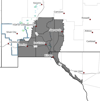
Weather
- Category: Weather
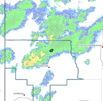 FLOOD ADVISORY IN EFFECT UNTIL 7 PM MDT THIS EVENING...
* WHAT...Arroyo and small stream flooding caused by excessive
rainfall is expected.
* WHERE...Portions of Grant County in Southwestern New Mexico, west
of Lake Roberts.
* WHEN...Until 700 PM MDT.
* IMPACTS...Water over roadways. Low water crossings along Highways
35 and 15 west of Lake Roberts may become inundated and
impassable. Run off is coming mostly from the north and is NOT
associated with the Trout Fire burn scar.
- Category: Weather
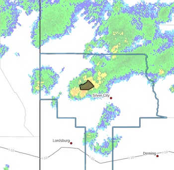 FLOOD ADVISORY IN EFFECT UNTIL 645 PM MDT THIS EVENING...
* WHAT...Arroyo and small stream flooding caused by excessive
rainfall is expected.
* WHERE...Portions of Grant County in Southwestern New Mexico.
* WHEN...Until 645 PM MDT.
* IMPACTS...Some low-water crossings may become impassable,
particularly along Bill Evans Road and Bill Evans Lake Road.
* ADDITIONAL DETAILS...
- Category: Weather
Low water crossings clear and dry. Removed from NM Roads.
ROAD ADVISORY
FLOODING – Rincon Area
Difficult Driving Conditions, NM 140 northbound and southbound from mile marker 0, at NM 185 to mile marker 2 Rincon.
Standing water on roadway. Use extreme caution.
FLOODING – Hatch Area
Difficult Driving Conditions, NM 154 eastbound and westbound from mile marker 0 Hatch to mile marker 4.
Standing water on roadway. Use extreme caution.
FLOODING – Hatch to Radium Springs Area
Difficult Driving Conditions, NM 185 northbound and southbound from mile marker 22, 7 miles north of Radium Springs to mile marker 33, 1 mile north of Angostura. Standing water on roadway. Use extreme caution.
When the roadway is flooded do not cross and seek an alternate route. Turn around, don't drown.
- Category: Weather
Roads were temporarily closed but are now open.
HIGH WIND WEATHER ADVISORY:
High wind warning in Hildago & Luna Counies, visibility is low in areas due to blowing dust. High profile vehicles please use caution. The NMDOT will continue monitoring the roadway. This event will be updated as conditions change.
[Editor's Note: I didn't post the weather forecast for it, because it takes too long to resize the photos and straighten out the mess of their text. If the wind is blowing hard, be prepared for there to be road issues on I-10 in the two counties and on some of their other roads, too. Be the smart people you are and keep track of the weather, often by just looking out the window, and be prepared!]
- Category: Weather
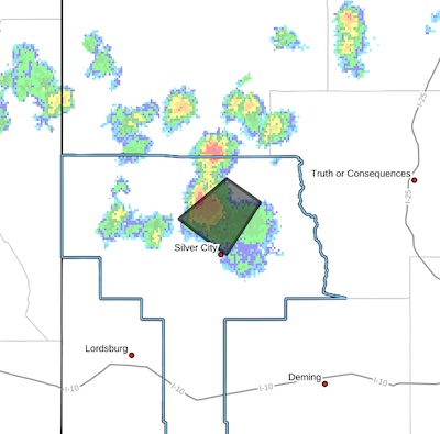
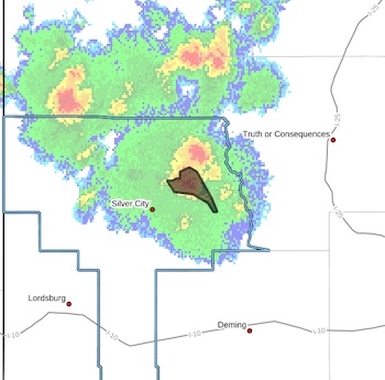 Flash Flood Warning
National Weather Service El Paso Tx/Santa Teresa NM
217 PM MDT Sun Jul 13 2025
The National Weather Service in El Paso Tx/Santa Teresa has issued a
* Flash Flood Warning for...
The Trout Fire Burn Scar in...
Northeastern Grant County in southwestern New Mexico...
* Until 430 PM MDT.
* At 217 PM MDT, Doppler radar indicated thunderstorms producingheavy rain over the Trout Fire Burn Scar. Between 0.1 and 0.3 inches of rain have fallen. Flash flooding is ongoing or expected to begin shortly.
- Category: Weather
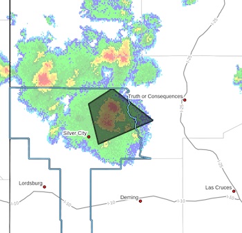 Severe Thunderstorm Warning
National Weather Service El Paso TX
226 PM MDT Sun Jul 13 2025
The National Weather Service in El Paso has issued a
* Severe Thunderstorm Warning for...Northeastern Grant County in southwestern New Mexico...West central Sierra County in south central New Mexico...
* Until 315 PM MDT.
* At 226 PM MDT, a severe thunderstorm was located near Gattons Park,moving east at 15 mph.
HAZARD...60 mph wind gusts and quarter size hail.
SOURCE...Radar indicated.
- Category: Weather
 Southwest Desert/Mimbres Basin-Sierra County Lakes-Northern Dona Ana County-Southern Dona Ana County/Mesilla Valley-West Central Tularosa Basin/White Sands-East Central Tularosa Basin/Alamogordo- Southeast Tularosa Basin-Western El Paso County-Eastern/Central El Paso County-Rio Grande Valley of Eastern El Paso/Western Hudspeth Counties-Rio Grande Valley of Eastern Hudspeth County- Including the cities of Truth Or Consequences, East and Northeast El Paso, Fabens, Derry, White Sands Range Headquarters, Tornillo, Orogrande, Chaparral, Vado, Deming, Las Cruces, Tularosa, Hatch, Garfield, Sunland Park, Columbus, Socorro, Radium Springs, Upper Valley, West El Paso, Holloman AFB, Alamogordo, Fort Hancock,
Indian Hot Springs, White Sands National Park, Spaceport, Fort Bliss, and Downtown El Paso
1112 AM MDT Thu Jul 10 2025
...HEAT ADVISORY IN EFFECT FROM 11 AM TO 9 PM MDT FRIDAY...
- Category: Weather
 Upper Gila River Valley NM-
Southern Gila Region Highlands/Black Range NM-
Central Grant County/Silver City Area NM-
233 PM MDT Wed Jul 9 2025
...A STRONG THUNDERSTORM WILL IMPACT NORTH CENTRAL GRANT COUNTY
THROUGH 300 PM MDT...
At 230 PM MDT, a strong thunderstorm was located near Lake Roberts, moving southwest at 15 mph. This storm may intensify as it tracks
along Highway 15 and approaches the Pinos Altos Range.
Brief heavy downpours are possible, but flash flooding is not anticipated on the Trout Fire Burn Scar. The storm is moving fast enough to limit precipitation, and is affecting an area with low
burn intensity.


Content on the Beat
WARNING: All articles and photos with a byline or photo credit are copyrighted to the author or photographer. You may not use any information found within the articles without asking permission AND giving attribution to the source. Photos can be requested and may incur a nominal fee for use personally or commercially.
Disclaimer: If you find errors in articles not written by the Beat team but sent to us from other content providers, please contact the writer, not the Beat. For example, obituaries are always provided by the funeral home or a family member. We can fix errors, but please give details on where the error is so we can find it. News releases from government and non-profit entities are posted generally without change, except for legal notices, which incur a small charge.
NOTE: If an article does not have a byline, it was written by someone not affiliated with the Beat and then sent to the Beat for posting.
Images: We have received complaints about large images blocking parts of other articles. If you encounter this problem, click on the title of the article you want to read and it will take you to that article's page, which shows only that article without any intruders.
New Columnists: The Beat continues to bring you new columnists. And check out the old faithfuls who continue to provide content.
Newsletter: If you opt in to the Join GCB Three Times Weekly Updates option above this to the right, you will be subscribed to email notifications with links to recently posted articles.
Editor's Notes
It has come to this editor's attention that people are sending information to the Grant County Beat Facebook page. Please be aware that the editor does not regularly monitor the page. If you have items you want to send to the editor, please send them to editor@grantcountybeat.com. Thanks!
Here for YOU: Consider the Beat your DAILY newspaper for up-to-date information about Grant County. It's at your fingertips! One Click to Local News. Thanks for your support for and your readership of Grant County's online news source—www.grantcountybeat.com
Feel free to notify editor@grantcountybeat.com if you notice any technical problems on the site. Your convenience is my desire for the Beat. The Beat totally appreciates its readers and subscribers!
Compliance: Because you are an esteemed member of The Grant County Beat readership, be assured that we at the Beat continue to do everything we can to be in full compliance with GDPR and pertinent US law, so that the information you have chosen to give to us cannot be compromised.
Submitting to the Beat
Those new to providing news releases to the Beat are asked to please check out submission guidelines at https://www.grantcountybeat.com/about/submissions. They are for your information to make life easier on the readers, as well as for the editor.
Advertising: Don't forget to tell advertisers that you saw their ads on the Beat.
Classifieds: We have changed Classifieds to a simpler option. Check periodically to see if any new ones have popped up. Send your information to editor@grantcountybeat.com and we will post it as soon as we can. Instructions and prices are on the page.