

 Click to Search
Search
[{{{type}}}] {{{reason}}}
{{/data.error.root_cause}}
{{{_source.title}}} {{#_source.showPrice}} {{{_source.displayPrice}}} {{/_source.showPrice}}
{{#_source.showLink}} {{/_source.showLink}} {{#_source.showDate}}{{{_source.displayDate}}}
{{/_source.showDate}}{{{_source.description}}}
{{#_source.additionalInfo}}{{#_source.additionalFields}} {{#title}} {{{label}}}: {{{title}}} {{/title}} {{/_source.additionalFields}}
{{/_source.additionalInfo}}
Weather
- Category: Weather
HIGH WIND WEATHER ADVISORY:
High wind warning in Hidalgo County, visibility is low in areas due to blowing dust. High profile vehicles please use caution. The NMDOT will continue monitoring the roadway. This event will be updated as conditions change.
- Category: Weather
 FLOOD ADVISORY IN EFFECT UNTIL 845 PM MDT THIS EVENING...
* WHAT...Flooding caused by excessive rainfall is expected.
* WHERE...A portion of southwest New Mexico, including the following county, Grant.
* WHEN...Until 845 PM MDT.
* IMPACTS...Minor flooding in low-lying and poor drainage areas. Water over roadways. River or stream flows are elevated.
* ADDITIONAL DETAILS...
- At 650 PM MDT, Doppler radar indicated heavy rain due to thunderstorms. Minor flooding is ongoing or expected to begin shortly in the advisory area. Between 0.5 and 1 inch of rain has fallen.
- Category: Weather
 FLOOD WARNING IN EFFECT ALONG PORTIONS OF THE MIMBRES RIVER UNTIL
1015 PM MDT THIS EVENING...
* WHAT...Small stream flooding.
* WHERE...Portions of the Mimbres River in Grant and Luna Counties in New Mexico.
* WHEN...Until 1015 PM MDT.
* IMPACTS...Flooding of river fords and low water crossings on
public roads and private driveways is expected, and may cut off
access to homes and farms on the left bank of the river. Flooding
may also impact the area near the Royal John Mine Road bridge at the confluence of the Mimbres River and Gallinas Canyon.
* ADDITIONAL DETAILS...
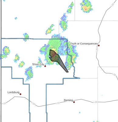
- Category: Weather
 FLOOD ADVISORY IN EFFECT UNTIL 345 PM MDT THIS AFTERNOON...* WHAT...Arroyo and small stream flooding caused by excessive rainfall is expected.* WHERE...Portions of south central and southwest New Mexico, including the following counties, in south central New Mexico, Sierra. In southwest New Mexico, Grant.* WHEN...Until 345 PM MDT.* IMPACTS...Rises in small streams and normally dry arroyos.*
ADDITIONAL DETAILS...
- At 1222 PM MDT, Doppler radar indicated heavy rain due to thunderstorms. This will cause arroyo and small stream
flooding. Between 1 and 1.5 inches of rain have fallen.
- This includes the following streams and drainages...
Berrenda Creek, Gavilan Arroyo, Middle Percha Creek and
Mimbres River.
- Some locations that may experience flooding include...
Sherman, Emory Pass and San Juan.
- Category: Weather
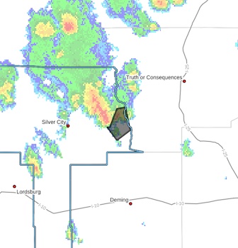
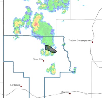
 Flash Flood Warning
National Weather Service El Paso Tx/Santa Teresa NM
1204 PM MDT Fri Jul 18 2025
The National Weather Service in El Paso Tx/Santa Teresa has issued a
* Flash Flood Warning for...
The Trout Fire Burn Scar in...
Northeastern Grant County in southwestern New Mexico...
* Until 300 PM MDT.
* At 1204 PM MDT, Doppler radar indicated thunderstorms producing,heavy rain over the Trout Fire Burn Scar. Between 1 and 1.5 inches,of rain have fallen. Flash flooding is ongoing or expected to
begin shortly.
Excessive rainfall over the burn scar will result in debris flow
moving through the Trout Fire Burn Scar, into canyons flowing east
towards the Mimbres River, including Three Circle, Soldiers,
Cottonwood, and Bear Canyons. The Mimbres River will also be
impacted. The debris flow can consist of rock, mud, vegetation and
other loose materials.
- Category: Weather
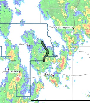
 FLOOD ADVISORY IN EFFECT UNTIL 715 PM MDT THIS EVENING...
* WHAT...Urban and small stream flooding caused by excessive rainfall is expected.
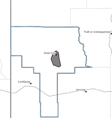
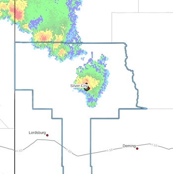
* WHERE...A portion of southwest New Mexico, including the following county, Grant. Specifically Silver City, and the surrounding area.
* WHEN...Until 715 PM MDT.
* IMPACTS...Minor flooding in low-lying and poor drainage areas. Some low-water crossings may become impassable.
* ADDITIONAL DETAILS...
- At 521 PM MDT, Doppler radar indicated heavy rain due to thunderstorms. This will cause urban and small stream
flooding. Between 0.5 and 1 inch of rain has fallen.
- Category: Weather
 Grant NM-
254 PM MDT Wed Jul 16 2025
...FLOOD ADVISORY IN EFFECT UNTIL 6 PM MDT THIS EVENING...
* WHAT...Arroyo and small stream flooding caused by excessive rainfall is expected.
* WHERE...A portion of southwest New Mexico, including the following county, Grant. Specifically over the Trout Fire Burn Scar.
* WHEN...Until 600 PM MDT.
* IMPACTS...Minor flooding in low-lying and poordrainage areas. Rises in small streams and normally dry arroyos.
* ADDITIONAL DETAILS...
- Category: Weather
HIGH WIND WEATHER ADVISORY:
High wind warning in Hildago County, visibility is low in areas due to blowing dust. High profile vehicles please use caution. The NMDOT will continue monitoring the roadway. This event will be updated as conditions change.


Content on the Beat
WARNING: All articles and photos with a byline or photo credit are copyrighted to the author or photographer. You may not use any information found within the articles without asking permission AND giving attribution to the source. Photos can be requested and may incur a nominal fee for use personally or commercially.
Disclaimer: If you find errors in articles not written by the Beat team but sent to us from other content providers, please contact the writer, not the Beat. For example, obituaries are always provided by the funeral home or a family member. We can fix errors, but please give details on where the error is so we can find it. News releases from government and non-profit entities are posted generally without change, except for legal notices, which incur a small charge.
NOTE: If an article does not have a byline, it was written by someone not affiliated with the Beat and then sent to the Beat for posting.
Images: We have received complaints about large images blocking parts of other articles. If you encounter this problem, click on the title of the article you want to read and it will take you to that article's page, which shows only that article without any intruders.
New Columnists: The Beat continues to bring you new columnists. And check out the old faithfuls who continue to provide content.
Newsletter: If you opt in to the Join GCB Three Times Weekly Updates option above this to the right, you will be subscribed to email notifications with links to recently posted articles.
Editor's Notes
It has come to this editor's attention that people are sending information to the Grant County Beat Facebook page. Please be aware that the editor does not regularly monitor the page. If you have items you want to send to the editor, please send them to editor@grantcountybeat.com. Thanks!
Here for YOU: Consider the Beat your DAILY newspaper for up-to-date information about Grant County. It's at your fingertips! One Click to Local News. Thanks for your support for and your readership of Grant County's online news source—www.grantcountybeat.com
Feel free to notify editor@grantcountybeat.com if you notice any technical problems on the site. Your convenience is my desire for the Beat. The Beat totally appreciates its readers and subscribers!
Compliance: Because you are an esteemed member of The Grant County Beat readership, be assured that we at the Beat continue to do everything we can to be in full compliance with GDPR and pertinent US law, so that the information you have chosen to give to us cannot be compromised.
Submitting to the Beat
Those new to providing news releases to the Beat are asked to please check out submission guidelines at https://www.grantcountybeat.com/about/submissions. They are for your information to make life easier on the readers, as well as for the editor.
Advertising: Don't forget to tell advertisers that you saw their ads on the Beat.
Classifieds: We have changed Classifieds to a simpler option. Check periodically to see if any new ones have popped up. Send your information to editor@grantcountybeat.com and we will post it as soon as we can. Instructions and prices are on the page.