

 Click to Search
Search
[{{{type}}}] {{{reason}}}
{{/data.error.root_cause}}
{{{_source.title}}} {{#_source.showPrice}} {{{_source.displayPrice}}} {{/_source.showPrice}}
{{#_source.showLink}} {{/_source.showLink}} {{#_source.showDate}}{{{_source.displayDate}}}
{{/_source.showDate}}{{{_source.description}}}
{{#_source.additionalInfo}}{{#_source.additionalFields}} {{#title}} {{{label}}}: {{{title}}} {{/title}} {{/_source.additionalFields}}
{{/_source.additionalInfo}}
Weather
- Category: Weather
ROAD ADVISORIES
FLOODING – Virden Area
NM 92 from mimilepost .5 to 5 has water running over the roadway at low water crossings, roadway is still passable. NMDOT is currently monitoring and will notify as conditions change.
When the roadway is flooded do not cross and seek an alternate route. Turn around, don't drown.
FLOODING – Mimbres/Lake Roberts Area
NM 35 from milepost 27 to 5, Mimbres, has water running over the roadway at low water crossings, roadway is still passable. NMDOT is currently monitoring and will notify as conditions change.
When the roadway is flooded do not cross and seek an alternate route. Turn around, don’t drown.
- Category: Weather
 FLOOD ADVISORies IN EFFECT UNTIL 9 PM MDT THIS EVENING...
* WHAT...Arroyo and small stream flooding caused by excessive
rainfall is expected.
* WHERE...A portion of southwest New Mexico, including the following
county, Grant.
* WHEN...Until 900 PM MDT.
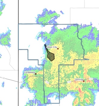
- Category: Weather
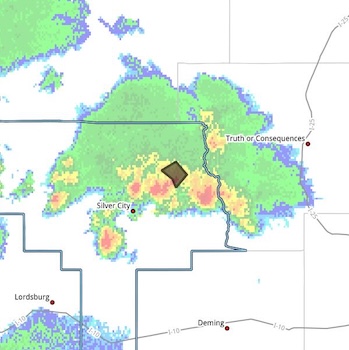
 Flash Flood Warning
National Weather Service El Paso Tx/Santa Teresa NM
531 PM MDT Thu Sep 25 2025
The National Weather Service in El Paso Tx/Santa Teresa has issued a
* Flash Flood Warning for...
Central Grant County in southwestern New Mexico...
* Until 830 PM MDT.
* At 531 PM MDT, Doppler radar indicated thunderstorms producing heavy rain across the warned area. Between 0.5 and 1.5 inches of
rain have fallen. Additional rainfall amounts of 0.5 to 1.5 inches are possible in the warned area. Flash flooding is ongoing or expected to begin shortly.
HAZARD...Flash flooding caused by thunderstorms.
SOURCE...Radar.
IMPACT...Flash flooding of small creeks and streams, urban
areas, highways, streets and underpasses as well as
other poor drainage and low-lying areas.
* Some locations that will experience flash flooding include...
Silver City, Bayard, North Hurley, Santa Clara, Fort Bayard and
Arenas Valley.
PRECAUTIONARY/PREPAREDNESS ACTIONS...
In hilly terrain there are numerous low water crossings which are
potentially dangerous in heavy rain. Do not attempt to cross flooded
roads. Find an alternate route.
Remain alert for flooding even in locations not receiving rain.
Arroyos, streams, and rivers can become raging killer currents in a
matter of minutes, even from distant rainfall.
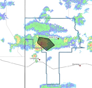
- Category: Weather
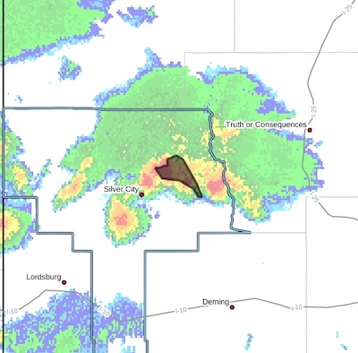 Flash Flood Warning
National Weather Service El Paso Tx/Santa Teresa NM 442 PM MDT Thu Sep 25 2025
The National Weather Service in El Paso Tx/Santa Teresa has issued a
* Flash Flood Warning for...
The Trout Fire Burn Scar in...Northeastern Grant County in southwestern New Mexico...
* Until 700 PM MDT.
* At 442 PM MDT, Doppler radar indicated thunderstorms producing heavy rain over the Trout Fire Burn Scar. Between 0.8 and 1.4
inches of rain have fallen. Additional rainfall amounts of 0.5 to 1.5 inches are possible in the warned area. Flash flooding is ongoing or expected to begin shortly.
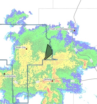
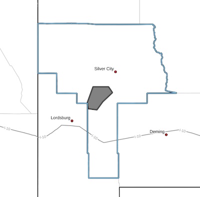
- Category: Weather
 Flash Flood Warning
National Weather Service El Paso Tx/Santa Teresa NM
407 PM MDT Thu Sep 25 2025
The National Weather Service in El Paso Tx/Santa Teresa has issued a
* Flash Flood Warning for...
North Central Grant County in southwestern New Mexico...
* Until 715 PM MDT.
* At 407 PM MDT, Doppler radar indicated thunderstorms producing heavy rain across the warned area. Between 1 and 1.5 inches of rain have fallen. Additional rainfall amounts of 0.5 to 1.5 inches are possible in the warned area. Flash flooding is ongoing or expected to begin shortly.
HAZARD...Flash flooding caused by thunderstorms.
SOURCE...Radar.
IMPACT...Flash flooding of small creeks and streams, urban
areas, highways, streets and underpasses as well as
other poor drainage and low-lying areas.
* Some locations that will experience flash flooding include...
Cottonwood Canyon, Soldiers Canyon, Three Circle Canyon, Allie
Canyon, Gattons Park, Camp Thunderbird and Upper Mimbres Valley.
Rain is falling near the northern edge of the Trout fire burn scar.
Some debris may be included in runnoff.
PRECAUTIONARY/PREPAREDNESS ACTIONS...
In hilly terrain there are numerous low water crossings which are
potentially dangerous in heavy rain. Do not attempt to cross flooded
roads. Find an alternate route.
Remain alert for flooding even in locations not receiving rain.
Arroyos, streams, and rivers can become raging killer currents in a
matter of minutes, even from distant rainfall.
- Category: Weather
 FLOOD ADVISORY IN EFFECT UNTIL 845 PM MDT THIS EVENING...
* WHAT...Arroyo and small stream flooding caused by excessive
rainfall is expected.
* WHERE...A portion of southwest New Mexico, including the following county, Grant.
* WHEN...Until 845 PM MDT.
* IMPACTS...Minor flooding in low-lying and poor drainage areas.Rises in small streams and normally dry arroyos.
* ADDITIONAL DETAILS...
- At 648 PM MDT, Doppler radar indicated heavy rain due to thunderstorms. This will cause arroyo and small stream flooding. Between 0.5 and 1 inch of rain has fallen.
- Category: Weather
 FLOOD ADVISORY IN EFFECT UNTIL 315 PM MDT THIS AFTERNOON...
* WHAT...Flooding caused by excessive rainfall is expected.
* WHERE...A portion of southwest New Mexico, including the following county, Grant.
* WHEN...Until 315 PM MDT.
* IMPACTS...Minor flooding in low-lying and poor drainage areas.
* ADDITIONAL DETAILS...
- At 119 PM MDT, Doppler radar indicated heavy rain due to
thunderstorms. Minor flooding is ongoing or expected to begin shortly in the advisory area. Up to 1 inch of rain has
fallen.
- Category: Weather
FLOODING – Animas Area
Difficult Driving Conditions, NM 9 eastbound and westbound from mile marker 1 to mile marker 2, 2 mile east of Arizona Stateline. Standing water on roadway. Use extreme caution.
When the roadway is flooded do not cross and seek an alternate route. Turn around, don't drown.


Content on the Beat
WARNING: All articles and photos with a byline or photo credit are copyrighted to the author or photographer. You may not use any information found within the articles without asking permission AND giving attribution to the source. Photos can be requested and may incur a nominal fee for use personally or commercially.
Disclaimer: If you find errors in articles not written by the Beat team but sent to us from other content providers, please contact the writer, not the Beat. For example, obituaries are always provided by the funeral home or a family member. We can fix errors, but please give details on where the error is so we can find it. News releases from government and non-profit entities are posted generally without change, except for legal notices, which incur a small charge.
NOTE: If an article does not have a byline, it was written by someone not affiliated with the Beat and then sent to the Beat for posting.
Images: We have received complaints about large images blocking parts of other articles. If you encounter this problem, click on the title of the article you want to read and it will take you to that article's page, which shows only that article without any intruders.
New Columnists: The Beat continues to bring you new columnists. And check out the old faithfuls who continue to provide content.
Newsletter: If you opt in to the Join GCB Three Times Weekly Updates option above this to the right, you will be subscribed to email notifications with links to recently posted articles.
Editor's Notes
It has come to this editor's attention that people are sending information to the Grant County Beat Facebook page. Please be aware that the editor does not regularly monitor the page. If you have items you want to send to the editor, please send them to editor@grantcountybeat.com. Thanks!
Here for YOU: Consider the Beat your DAILY newspaper for up-to-date information about Grant County. It's at your fingertips! One Click to Local News. Thanks for your support for and your readership of Grant County's online news source—www.grantcountybeat.com
Feel free to notify editor@grantcountybeat.com if you notice any technical problems on the site. Your convenience is my desire for the Beat. The Beat totally appreciates its readers and subscribers!
Compliance: Because you are an esteemed member of The Grant County Beat readership, be assured that we at the Beat continue to do everything we can to be in full compliance with GDPR and pertinent US law, so that the information you have chosen to give to us cannot be compromised.
Submitting to the Beat
Those new to providing news releases to the Beat are asked to please check out submission guidelines at https://www.grantcountybeat.com/about/submissions. They are for your information to make life easier on the readers, as well as for the editor.
Advertising: Don't forget to tell advertisers that you saw their ads on the Beat.
Classifieds: We have changed Classifieds to a simpler option. Check periodically to see if any new ones have popped up. Send your information to editor@grantcountybeat.com and we will post it as soon as we can. Instructions and prices are on the page.